One of the fun activities to do in the outdoors is identifying different species of flora and fauna. It’s about more than knowing names; the process of identification brings us closer to the world around us and tells us what’s going in that habitat.
The same can be said for knowing the different species of cloud. Being able to recognise the different types of clouds and what they’re doing tells us what’s happening with the weather, and when our risk is increasing or decreasing. This is an especially important skill for those who spend a lot of time in the mountains.
We talked to Sarvesh Garimella, the chief scientist and COO at MyRadar, a Suunto partner, about the different varieties of clouds and what we should look out for when we’re planning to head into the great outdoors. A keen hiker since his field research days at university, Sarvesh has a Phd on ice clouds in the atmosphere. Who better to ask then? Here are Savesh’s 10 tips.
Click to find out more about MyRadar’s detailed local weather forecasts!
Download MyRadar Wear OS app here.
Respect the mountain
At a really high level, clouds are one type of information your surroundings are giving you. We can also look at recent weather and trail reports about an area. And one of the most important recommendations that has been echoed to me again and again is to know your limits and respect the mountain. There could be hazards you are prepared for and others you aren't prepared for. No climb or trip is worth your life. Be smart and live to climb another day.
The trend is your friend
In forecasting we like to say this phrase a lot: "the trend is your friend." If you’re just looking at what the barometer is saying in one moment that’s less informative than observing what the trend is. Or if you’re looking at a model of rain output, the model that came out an hour ago might not show as much output as the model that came out just now does. If you look at the next model an hour later it might be showing more rain. Each successive model is showing more and more rain or whatever phenomena. Whether it be simple observation of the environment or more sophisticated analysis of weather models, the trend is your friend. Just because you have a snapshot of what’s going on now that doesn’t mean you have a complete idea of what it could turn into, especially in a complex environment.

Sarvesh regularly hikes in the Pacific Northwest.
Know your cloud
The World Meteorological Organisation (WMO) has an International Cloud Atlas that consists of 10 genus of clouds within which there are many species of cloud. Within the species of clouds there are lots of different varieties. The WMO website has flow charts and guidance to help you identify what specific types of clouds you are looking at.
The big three
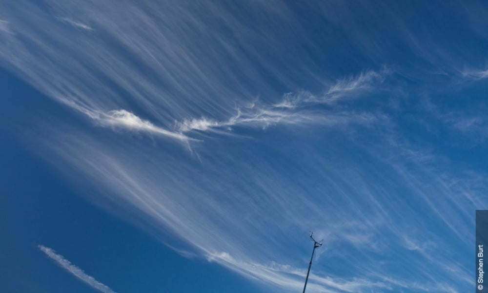
For most people I say there are only three types of clouds to think about. Those are the cirrus clouds, which are the wispy ice clouds that tend to be higher in the atmosphere. Most of the clouds you see that are puffy and popcorn-like are cumulus clouds, and those tend to be scattered and independent. Then you have stratus clouds, the decks of extensive, and low to medium altitude clouds. These are the low clouds that stretch out as far as you see that produce gentle spitting rain. There is a qualifier for various types of clouds: whenever you hear the word nimbus it refers to rain. Cumulonimbus clouds, for example, can turn into a thunder head. So the big three are: cirrus, cumulus, and stratus clouds.
1. Cirrus clouds

2. Cumulus clouds

3. Stratus cloud

Watch the low clouds
In addition to those three main types of clouds you can also classify clouds by their altitude. Low, medium and high clouds. It’s good to identify what could be happening in the low cloud decks versus the middle or high cloud decks. If you see there are a few wispy cirrus clouds in the morning, and then you see a few more in the afternoon, that could suggest there might be more moisture entering into the region, but it might not pose an immediate risk. But if your low cloud decks seem sketchy and visibility is poor you might like to wait another hour or two for the sun to come up to see if it burns off the fog. I’ve been on climbs where we’ve definitely had risk issues with the low or medium cloud deck, especially on Mt Rainier.
Not all clouds are bad
When I see a stratus deck that is low and consistent, with spitting rain, that’s a good sign for me because it means it’s not the nicest from a hiking standpoint, which means there is going to be less people out on the trail. Just because you see rain it doesn’t mean you are going to have a bad time.
Beware of lenticular clouds
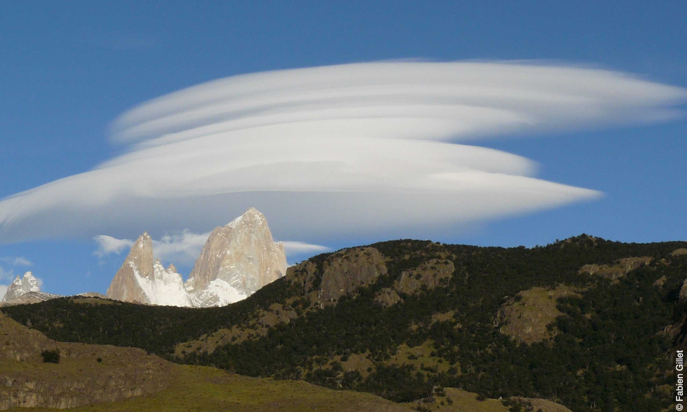
Here's one particular example especially relevant for mountain climbing; a lenticular cloud. These are the lens shaped clouds that sit on top of mountains. They tend to form when you have moist air moving across the landscape, which gets kicked upwards by the mountain itself. They are pretty to look at, but what you have to keep in mind, especially on the leeward side of the mountain, is it means you get lots of vortex shedding from wind coming over the mountain. Pilots know to stay away from lenticular clouds because the turbulence there can be really bad. Wind risk can be more significant than any other type of hazard depending on the mountain you are on. If you see a lenticular cloud it suggests that there might be windier conditions as you get closer to the summit.

Watch for vertical extent
The thinner, wispy clouds higher up are less of an issue to look out for than low clouds. The stratus decks can produce steady, low intensity rain, but from a hazard standpoint they aren’t particularly dangerous. If you have instability in the atmosphere or the chance for developing thunderstorms, that is the sort of hazard you want to look out for. If you notice the cloud cover is significantly higher than it was first thing in the morning or the vertical extent of the clouds is increasing then its ability to start producing rain also increases.
Be aware of cooling
If you feel the air getting cool and if you can see the pressure is dropping this might be because a weather cell is moving towards your area. The up and down draughts and the rain and the cooling effects of the rain can change the weather pretty dramatically. That can be a sign of quickly changing weather. This is one of the reasons why My Radar has the precipitation nowcasts; they warn you when it sees a cell on a radar that you might not necessarily be able to pay attention to. Remember, the trend is your friend.
Read trail reports
The trail reports put out by the fire service, the AllTrails App and such are definitely important as well. Many of the hazards are only present if the trail is in a certain condition. If you have lots of wind that might be okay if you have lots of traction. But if you have ice on the ground and also gusting winds that’s another issue.
Add MyRadar Wear OS app on your Suunto 7 to get detailed local weather forecasts on your wrist.
Lead image: ©Philipp Reiter
Other images by Marc Thunis on Unsplash
